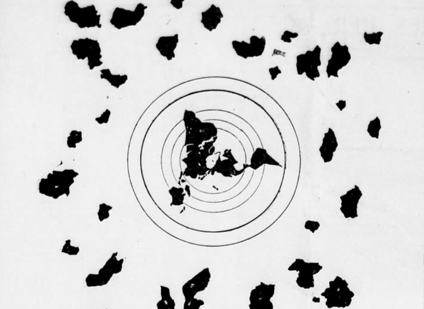
Published in The Gazette of Honolulu, Hawaii Fri, Jan 11, 1907; This map is assured to be 1,000 years old by a well known and respected Japanese Physician, and Surgeon; Dr. Kobayashi, who supplied it. See the article below:

And here’s the entire original Paper for your viewing pleasure, courtesy of Santo:
The Hawaiian Gazette (Honolulu, Hawaii).
Volume 50, Issue 4, 1907-01-11.
Full Article Text:
Stranger almost than the “Manuscript found in a Copper Cylinder” is the copy of a map which came across seas to Honolulu from a Buddhist Temple in the mountains of central Japan. It is a map of the world made 1000 years ago. Dr. Kobayashi, the well-known Japanese physician and surgeon of Honolulu, has received a copy of the map, which he believes to have been made by Chinese priests ten centuries ago.
The map is drawn on the principle of the Mercator Projection showing the North Pole as the center of a circle in which are the continents of North and South America, Europe, Africa, Asia and Australia.
“The map was found by my brother in a Japanese temple in the mountains of Japan,” said Dr. Kobayashi. “It has been hidden from the Japanese government in modern times just as it was in ancient times, for in olden days such a map would have been destroyed by the authorities. According to a letter the original map was brought from China by a Buddhist priest and concealed in this temple.
“Ten years ago my brother was a consumptive. Although I was a physician he did not wish to be treated with medicines. He decided to go into the mountains and attempt a cure by himself. For ten years he has remained there and used his will power to effect a cure. Today he is a well man. During his stay there he found this map. He evolved from it a theory of the flatness of the earth, despite all modern facts showing it to be a sphere. This theory has been his one aim in life. He is an artist and in order to demonstrate his theory he made beautiful drawings, picturesque and attractive to the eye, in which mechanical, astronomical and engineering methods are shown.
“My brother goes back to the days of Columbus and Amerigo Vespucci who, he says, sailed for a new country believing that by sailing directly in one general direction they would ultimately come to the place.
“We moderns know that a vessel sailing from a port and going continually in a generally easterly manner will arrive at the same place. The vessel, of course, goes around the globe. My brother’s theory is that one sails about a vast plane as one would sail around the edges of a bowl.”
The illustrations accompanying the map are beautiful examples of Japanese art. No more attractive book of geography has ever been compiled. It is a mass of cherry blossoms, Fujiyamas, beautiful blue seas dotted with the sails of junks and sampans. There are landscapes and seascapes and bizarre pictures of Japanese women, designed along old-time styles. But in every sheet of such pictures the engineering lines are brought out in a way that does not mar the picture. With the text matter explaining each page, the geography should be easily understood.
Dr. Kobayashi now has all the original sheets, scores of them, and these he will return to Japan to his brother, who intends to have them put in the hands of publishers. It will be one of the most novel publications of the period.
The original map of which a copy drawn by Dr. Kobayashi’ s brother, and of which the accompanying cut is a tracing, is worm-eaten and barely holds together. The above map with all the continents and even the Hawaiian Islands shown, was evidently not made by the priests who traced the original lines.
If you found all that interesting, perhaps you’ll find the fact they’re admitting of the long known technology of anti-Gravity now; that the only thing that causes gravity is the equalization between positive and negative electrons, thus density applies, for the more dense, the more charged electrons found in every atom. So as you can see, we can charge anything, regardless of size, to levitate up, down, left, right, etc.
Leave comment